Winter Storm Warning: Issued for northeastern North Carolina and southeastern Virginia.
Expected Snowfall: Between 7 and 12 inches, with local areas seeing even more.
Strong Winds: Gusts of 50-60 mph expected.
Blizzard Conditions: Whiteout and blizzard-like conditions are possible.
Wind Chill: Temperatures will feel like 0°F on Sunday morning.
Tidal Flooding Risk: Especially for the Southside cities on Sunday morning.
Winter Storm Warning for Hampton Roads and Surrounding Areas
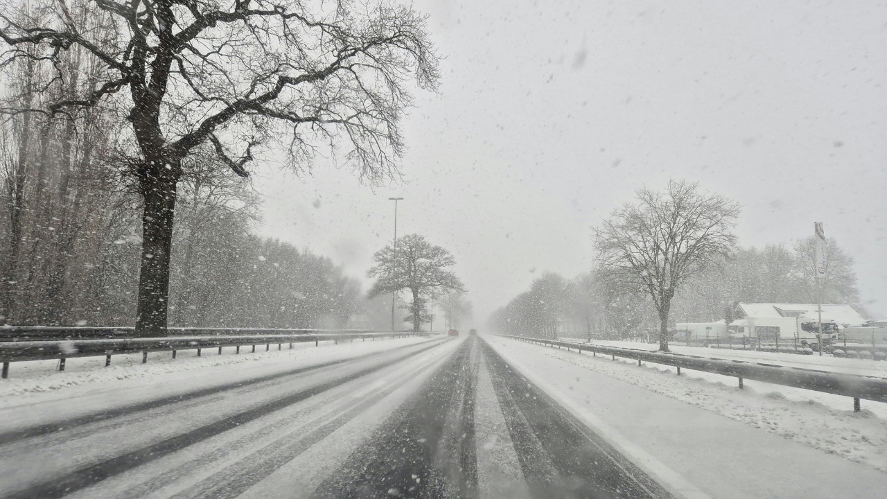
A Winter Storm Warning has been issued by the National Weather Service for areas in northeastern North Carolina and southeastern Virginia, including Hampton Roads. The warning predicts blizzard conditions and heavy snow in the region, along with strong winds and a wind chill that will bring temperatures to near freezing levels.
What to Expect:
Snowfall: The region is expected to see 7 to 12 inches of snow, with some areas potentially receiving more.
Wind Gusts: Winds will be between 50 and 60 mph, particularly along the coast, leading to possible whiteout conditions. Winds will remain strong throughout the weekend, and wind chill values will make it feel like temperatures are around 0°F by Sunday morning.
Tidal Flooding: The Southside cities and the Outer Banks are at risk for tidal flooding due to the strong winds pushing water against the shore.
Weather Forecast:
Snow: The snow is expected to begin on Saturday afternoon, with the heaviest snowfall coming in the evening and overnight hours, continuing into Sunday morning.
Difficult Travel: Road conditions will be treacherous, with the National Weather Service cautioning that travel will be potentially life-threatening due to whiteout conditions and snow accumulation.
Cold Temperatures: Temperatures will stay below freezing over the weekend, with highs in the upper 20s and lows in the low 20s.
Coastal Areas and Outer Banks at Greater Risk:
The Outer Banks will experience heavy snow, with accumulations ranging from 8 to 12 inches and wind gusts reaching 55 to 65 mph.
Ocracoke, Buxton, and other coastal areas will also experience blizzard-like conditions, with visibility dropping below a quarter mile due to blowing snow.
High Surf and Wind: High surf advisories are in effect, along with a coastal flood warning for areas like Hatteras Island.
Tidal Flooding and Travel Disruptions:
The North Carolina Department of Transportation has issued advisories urging residents to stay off the roads, especially in the Outer Banks, where the combination of snow, strong winds, and high tides may cause significant disruptions to travel and safety.
Impacts on Local Communities:
The storm is expected to affect schools, businesses, and traffic across the region. WAVY Meteorologists have warned of whiteout conditions, urging everyone to plan and stay home if possible.
Tidal flooding could severely affect the Chesapeake Bay, Northern Neck, and Lower Peninsula, with the strong winds pushing the water into the tidal rivers, potentially impacting roads and infrastructure.
Stay Safe and Prepare: Tips for the Winter Storm
Limit Travel: If possible, stay off the roads until conditions improve. The National Weather Service has warned of life-threatening travel conditions.
Stock Up on Supplies: Make sure you have enough food, water, and essentials to last through the storm.
Check on Neighbors: Especially the elderly or those who may need help during the storm.
Stay Warm: Bundle up, as wind chills will make it feel much colder than the actual temperature.
Monitor Weather Alerts: Stay updated on the latest forecasts and warnings to ensure you have the most accurate information.
Historical Context:
This storm comes 30 years after the East Coast Blizzard of 1996, which was one of the most significant winter storms in recent history. The region saw 21.8 inches of snow that winter, and the current storm could rival those totals depending on where the heaviest snow falls.
On the Water:
Mariners are advised to remain in port, as the storm will bring high winds and freezing spray to vessels, creating dangerous conditions on the water. The National Weather Service has issued several maritime warnings, including a storm warning and small craft advisories.
Conclusion: Prepare for a Wintry Weekend
The winter storm hitting the Hampton Roads area will bring challenging weather conditions, including heavy snow, strong winds, and blizzard conditions. It’s essential to stay safe, limit travel, and prepare for potential power outages and flooding. Keep monitoring local news and weather updates to stay informed as the storm progresses.