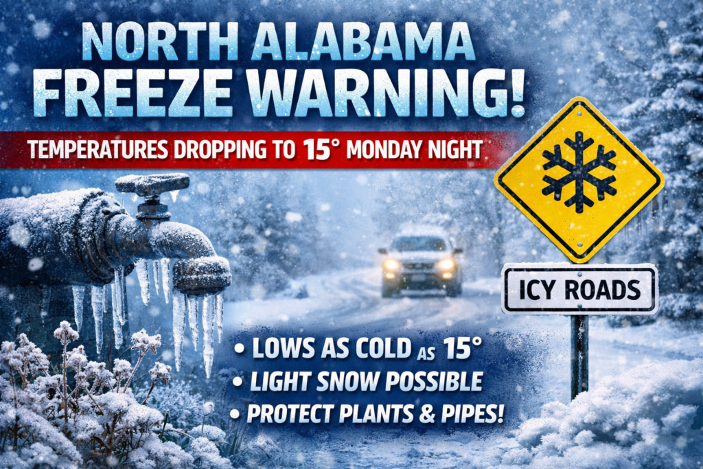
What North Alabama Needs to Know About This Freeze and Snow Threat
Freeze warning in effect: Monday 8 p.m. to Tuesday 9 a.m.
Coldest temperatures: Could fall as low as 15°F in parts of North Alabama
Areas impacted: Lauderdale, Colbert, Franklin, Lawrence, Limestone, Madison, Morgan, Marshall, Jackson, DeKalb, and Cullman counties
Snow is possible too: Some areas in North Alabama could see light snow or snow showers overnight into Monday
Accumulations look minor: Up to one-tenth of an inch may be possible in a few spots
Main risks: Damage to crops, sensitive plants, and outdoor plumbing, along with gusty winds and isolated power outages
Travel impacts: Major issues are not expected, but drivers should still use caution, especially in higher elevations and exposed areas
Cold sticks around: Chilly conditions are expected through Tuesday and Tuesday night, with a warm-up starting Wednesday
North Alabama Braces for Hard Freeze, Gusty Winds, and a Chance of Snow
North Alabama is in for a sharp blast of cold weather, with a freeze warning now in place from Monday evening through Tuesday morning.
According to the National Weather Service, temperatures could drop to as low as 15 degrees, creating dangerous conditions for plants, outdoor plumbing, and anything left exposed to the cold. The warning covers Lauderdale, Colbert, Franklin, Lawrence, Limestone, Madison, Morgan, Marshall, Jackson, DeKalb, and Cullman counties.
Freeze Warning Timing and What It Means
The warning begins at 8 p.m. Monday and continues until 9 a.m. Tuesday.
That means overnight and early morning hours will be the most dangerous period, especially for:
Sensitive plants and crops
Freezing temperatures at this level can kill tender plants and damage crops quickly.
Outdoor plumbing
Unprotected pipes and outdoor plumbing fixtures could freeze and suffer damage.
Loose outdoor items
Gusty winds may blow around unsecured objects, so it’s a good idea to bring them in or tie them down.
Wind Could Add to the Trouble
This cold snap is not just about freezing air. Forecasters are also warning about strong, gusty winds.
Those winds could:
Knock down tree limbs
A few weak limbs could come down as winds increase.
Cause isolated power outages
Some neighborhoods may see brief outages if limbs or debris affect power lines.
Make driving harder
High-profile vehicles, especially on open roads, may feel the strongest impacts from the gusts.
Yes, North Alabama Could See Snow
As colder air rushes in behind Sunday night’s storms, parts of North Alabama could also see light snow.
Forecasters in Huntsville say they are not expecting major travel problems, but minor accumulation of up to one-tenth of an inch is possible through Monday. In some places, snow could continue as late as Monday afternoon.
When the Snow Could Start
Storms are expected to move through North Alabama later Sunday night, possibly beginning between 8 p.m. and 11 p.m.
Once those storms move out, colder air will quickly move in. Forecasters say there may be a 3- to 5-hour window of light precipitation behind the front, and that rain could briefly change over to snow before ending.
There is also a chance for:
Another round of light snow on Monday morning
A separate band of light snow may develop and move into the area late Monday morning.
Snow showers in northeast Alabama
The best chance for lingering snow showers into Monday afternoon appears to be in northeast Alabama, especially in higher elevations.
Will Snow Be a Big Problem?
At this point, major impacts are not expected.
Ground temperatures have been relatively warm, which should help limit accumulation and road issues. Even so, a few slick spots cannot be ruled out in colder or elevated areas if brief snow bands develop.
Temperatures Will Stay Well Below Normal
Monday is expected to feel much colder than recent days, and some North Alabama spots may not even rise above freezing.
Cold weather is then expected to continue through:
Monday night
Lows in North Alabama could drop into the low 20s, with some places even colder
Tuesday
Another chilly day with below-normal temperatures
Tuesday night
Cold conditions will continue before warmer air begins to return
A Warm-Up Is Finally Coming
The good news is this cold blast will not last all week.
A warming trend is expected to begin on Wednesday, and by Thursday, much of Alabama should be back into the 60s and 70s.
How to Prepare Before the Freeze Arrives
With temperatures this low, it’s smart to take precautions now.
Protect plants
Bring sensitive plants indoors if possible. If not, cover them well before temperatures fall Monday night.
Protect pipes
Wrap exposed outdoor pipes and disconnect hoses to help prevent freezing damage.
Secure outdoor items
Trash cans, patio furniture, and other loose objects could be blown around by strong winds.
Be careful on the road
Drivers, especially those in trucks, vans, and SUVs, should stay alert for gusty winds and any brief snow showers.
Freeze Watch vs. Freeze Warning: What’s the Difference?
A freeze watch means conditions are favorable for freezing temperatures in the coming days.
A freeze warning means freezing temperatures are either expected or already occurring, and action should be taken right away to protect plants and property.
In this case, North Alabama has moved into the more serious stage: a freeze warning, with temperatures expected to fall well below freezing.
References:
https://www.al.com/weather-alerts/2026/03/freeze-warning-affecting-north-alabama-monday-and-tuesday-temperatures-to-dip-to-15.html
https://www.yahoo.com/news/articles/snow-possible-alabama-overnight-monday-130649839.html
https://abc3340.com/news/local/rain-moving-out-colder-air-move-into-alabama